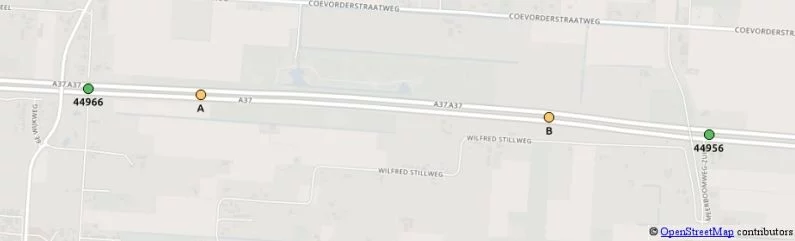
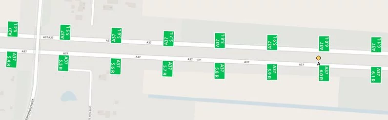
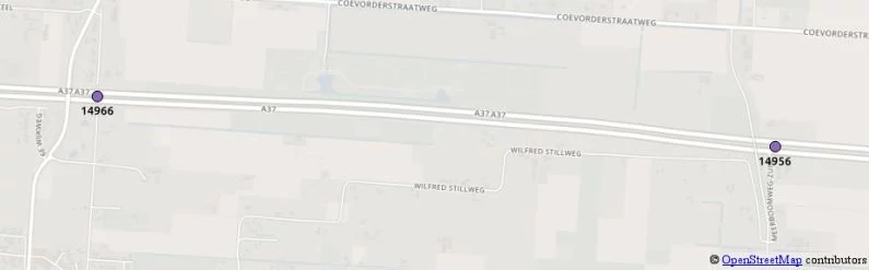
Linear location referencing methods
Part 2
How do linear location referencing methods work?
Traffic Message Channel
Let’s start with TMC (Traffic Message Channel). TMC works with a predefined fixed table of points. We can use the table to exactly describe the location of a traffic jam. As long as the sender and the receiver have a copy of the same table of points, these points can be used to communicate a location, right?

Offsets
But… what if the traffic jam starts at point A on the map and ends at point B? Is there a way in TMC to describe that, too? Let’s think about it. How would you explain such a location? Well, maybe like this: The traffic jam starts 440 meters after point 44966. It ends 630 meters before point 44956.
That works nicely! Using distances to or from the TMC points, enables us to describe any location. As long as the road is a TMC-road. These to/from distances are usually called offsets.
Linear location referencing
TMC is not the only method for linear location referencing. It is a very important one though, since TMC is supported in many countries in the world. In the remainder of this blog post, we will check out two other methods for linear location referencing. Methods which are widely used in the Netherlands.

BPS location describing method
BPS (Beschrijvende Plaatsaanduiding Systematiek roughly translates to location describing method) is a Dutch location referencing method. It is based on highway location markers next to the road. The markers are placed at every hectometer.
If we want to exactly describe the location of a traffic jam, we could use the information on the highway location marker. To be really precise, we could also use offsets to or from these markers. So that makes BPS a method for linear location referencing, too!
An example. To describe the start of the traffic jam at point A (see map below) in BPS, we could say: This traffic jam starts on road A37 on side R, 10 meters before kilometer 6.0 (A37 R 6.0 – 10).

The Netherlands is not the only country that uses these location signs. In fact, many motorways and secondary roads across the world are equipped with highway location markers. For example the United Kingdom and the United States.
VILD
VILD (Verkeers Informatie Locatie Database translates to traffic information location database) is also a Dutch system. And you might already be familiar with the general ideas, as VILD is an extension to TMC. There are some differences, though:
- VILD points have different numbers than their corresponding TMC points;
- VILD data structures also make a connection to road numbers and hectometers, to enable integration with BPS-based location references;
- VILD has a higher coverage than TMC.
This map shows the corresponding VILD points of the TMC points in the map above. In this case, the points are at exactly the same place, but the point numbers are different.

VILD is widely used in the Netherlands, for example at the NDW (Nationale Databank voor het Wegverkeer translates to national data warehouse for traffic). NDW is a national broker. Through NDW, various providers of traffic related data can distribute their data to many consumers. Currently, all locations in the NDW database are described using VILD. The XML data interchange format of the NDW follows an international standard: Datex II.
Principles of linear location referencing
Summary
- Sender and receiver need the same table (with e.g. TMC points);
- Locations are related to predefined references;
- These predefined references are often related to linear features such as roads (e.g. A37 side R);
- Offsets are used to describe deviations from these predefined references;
- Each method fits a specific use, so sometimes we need translation.
Pros and cons
Linear location referencing methods have in common that their representation is usually pretty small. They also share a disadvantage. Linear methods only support location referencing on supported roads.
Read more on how linear location referencing compares to other methods in Jeroen’s blogs:
‘Introduction to top location referencing methods’ (part 1) and ‘Location referencing and maps’ (part 3).
This might also interest you:

Linear location referencing methods
Understanding linear location referencing methods is crucial for precise navigation and transport management. These methods, such as route-based, relative, and absolute referencing, allow logistics and

Introduction to top location referencing methods
Location referencing is the foundation of modern logistics and transport management, enabling precise tracking, efficient route planning, and seamless supply chain operations. From geospatial coordinates