Introduction to top location referencing methods
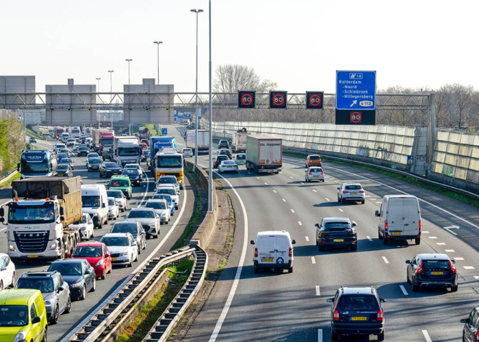
Describing the location of a traffic jam...
a beginner’s guide
Where is this traffic jam, exactly?
If I wanted to warn you about a traffic jam on your route, and I gave you GPS coordinates of the exact location, would you know where this congestion is? That could be challenging! Imagine I gave you the GPS coordinates of the orange dot on the map.
Which of the two roads is the traffic jam located on? The north/south one, or the east/west one? Even if you knew which road was meant, for example the north/south road, you couldn’t possibly know which direction: north or south. Furthermore, a traffic jam has a certain length, but there is only one orange dot on the map. Help!
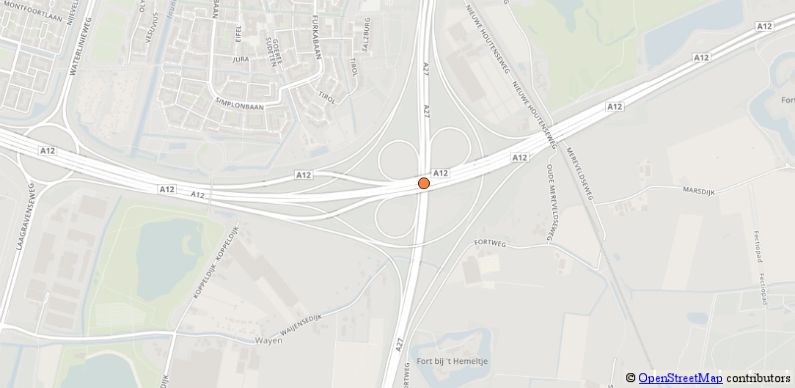
Communicating a single GPS point would not work, as shown by the example above. What would work? And, why should it work?
Traffic information needs location
To answer the last question first: Let’s say you have invested in a new car navigation device, which also supports live traffic information. This means that your navigation device knows where traffic jams are. And if those traffic jams are on the route it has planned for you, it might re-route you around those congestions.
Of course, your car navigation does not magically know the position of a traffic jam. It receives the congestion sites from a traffic service (more about that later) and then relates those sites to the route it has planned for you. Your navigation can do so pretty accurately (so you can rely on it). Still, we don’t know how your car navigation works.
On to answering the other question: What would work to describe the location of the traffic jam? We have seen that a single GPS point is not doing the trick. What will? This is where location referencing comes to help.
What is location referencing?
The process of exactly describing a location is called location referencing. The service that sends live traffic information to your car navigation device uses location referencing to communicate the positions of congestions. There are many ways to do location referencing. In the remainder of this blog post, I will briefly introduce the general ideas of two of the best-known methods: TMC and OpenLR.
TMC
Check out the map with the numbered green points. If I wanted to describe the position of a congestion, I could simply say something like:
This traffic jam starts at point 37264 and ends at point 37262.
Right? Since I have shown where these points are on the map before, you know exactly where this traffic jam is. In the future, I can use the same system of points to warn you about new delays on this road.
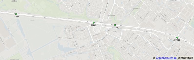
Please beware, a map for a computer is something different than for humans. For a computer, a map is a database that contains information about all roads and interconnections. TMC points have to be matched to the road network in the database.
Traffic information via TMC
This system is widely used in real life. It is called TMC, short for Traffic Message Channel. Remember the services that send live traffic information to your car navigation device? One such service is active on the RDS-channel of your FM Radio. This is how TMC works:
- Your car navigation contains a table with TMC points. When it receives the location of a traffic jam in TMC format, it can interpret this using the TMC table. It then relates this location to the route it has planned for you to warn you about congestions on your way. It might even propose a route that avoids the delay. TMCs compact representation makes TMC a very effective location referencing method for communicating traffic incidents over the RDS-channel.
There is a drawback to the TMC method. How would you describe an incident on a road that is not indexed in the table of points? Well, describing a site that is not covered by TMC is simply not possible. If the place does not exist in the TMC table, you cannot communicate about it. Fortunately, there are other location referencing methods that can help, for example OpenLR.
OpenLR
Let’s take a look at the map. The yellow line symbolizes a congestion. What would happen if I asked you to explain to me the place of the bottleneck? When I only had a map to look up your description, and nothing else?

Chances are that you would come up with something of the following form:
The traffic jam starts at lat/lon 52.093/5.174, where you drive to west. It ends at lat/lon 52.087/5.162, where you come from north. The entire jam is on a sliproad of a motorway. Just to be sure: The traffic jam is about 1950 meters long.
On the map, I have placed little green arrows at the start and at the end, based on the latitudes and longitudes mentioned. It would take me some time to look it up. Yet, this information is enough for me to find the exact location of the bottleneck. And doesn’t that make it a location reference? After all, location referencing is the process of exactly describing a location! Well yes. And what we just did, is basically the idea of OpenLR.
OpenLR is a location referencing method originally developed by TomTom and then donated as a free software project to the open source community. OpenLR describes start and end points, optionally via-points and characteristics of the road in between. Those little green arrows? They are called location reference points in OpenLR.
Digital radio DAB+
OpenLR is widely used for traffic information on the web. DAB+ digital radio will also support OpenLR for live traffic information. So in the future, your car navigation device could also receive information about traffic jams on non-TMC roads. This is the big advantage of OpenLR: that it can also describe roads that are not covered by TMC. This increased flexibility is not without cost: A location reference in OpenLR needs more bits than one in TMC. Transmitting and interpreting OpenLR requires more powerful hardware.
Translate between location referencing methods
In this blog post, I introduced the concept of location referencing and two of the best-known methods: TMC and OpenLR. No location referencing method is perfect and each has it’s own pros and cons. This is why multiple methods will always co-exist.
Future-proof traffic information
Specializing in location referencing methods is what we do at Simacan. Understanding the different methods well, enables accurate translation from one method to another. Without the technical difficulties, you can focus on what matters most to you: meaningful data. Meaningful data in the form of traffic information aids drivers on the road and spurs innovations for driverless cars and smart logistics.
Read more about location referencing in Jeroen's blogs 'Linear location referencing methods' (part 2) and 'Location referencing and maps' (part 3).